From Sousse to Kairouan, say hello to Tunisia on Street View
More than one billion of Google Maps’ daily users will now be able to explore Tunisia’s iconic roads and beaches as we launch 360-degree imagery in 15 of the country’s cities on Street View. In addition to the capital Tunis, Google Street View users will now be able to get to know 14 other cities in Tunisia: Bizerte, El Djem, Kairouan, Sousse, Ben Arous, Djerba, Gabes, Sfax, Agareb, Mahdia, Monastir, Nabeul, Hammamet, Yasmine Hammamet, and the roads which link the cities.
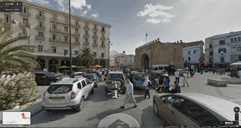
The iconic Bab Behr gateway as seen from Manji Sleem Street in Tunis
This imagery will be of use to both Tunisians and the country’s visitors. Tourists will now be able to explore the area around a certain hotel and scout it for cafes, shops, and public transportation. We worked with the Tunisian Ministry of Communication Technologies and Digital Economy to provide this unique and helpful experience for our users. We used the Street View Car which was outfitted with equipment to collect imagery: a panoramic camera to collect 360-degree views, lasers to capture distances to walls, and motion sensors to track the car’s position.
The beach at Sousse as seen from El Hadi Shaker Street

Tunisia is the first country in North Africa to be available on Street View and the 82nd in the world. In addition to street-level views, we also launched imagery in some of the region’s most iconic locations over the past few years such as Petra in Jordan, the Pyramids of Giza, and the Liwa Desert in Abu Dhabi, Dubai’s Burj Khalifa, and the Sheikh Zayed Grand Mosque in Abu Dhabi.
We look forward to launching more Arab cities on Street View giving users the chance to explore the incredible sights and landmarks in the region.


