Google Maps in India: Keeping You Informed with New Safety & Disruption Alerts
In a country as dynamic as India, conditions can change in an instant. Every day, we make millions of updates to Maps in India through our AI, partners, and user contributions to keep the map fresh and reliable.
We already partner with traffic police authorities in 18 cities to map road closures, disruptions and restrictions as soon as we are notified about them. These efforts are amplified by our local Maps community, which helps surface 150,000 disruptions daily—making India one of the top countries for such real-time, user-generated feedback. India reported the highest number of flood-related alerts on Maps globally this year, providing critical information to others on the road.
We know there is more to do, so we’re always working on new ways to help you stay informed of conditions ahead—whether it’s an unexpected traffic jam or a safety-critical area.
Beat traffic before you’re in it with Proactive Traffic Alerts
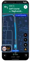
There’s nothing worse than getting on a familiar route only to be surprised by a sudden standstill. Now, Google Maps acts as your smart lookout, even if you're not actively navigating. We’re launching Proactive Traffic Alerts, which will automatically notify you when there’s a major disruption or delay on the road ahead. You'll know how bad the delay is and how much time will be added to your ETA. India is one of the first markets, along with the U.S., where we are rolling this out to Android users for highways and major roads in New Delhi, Mumbai, and Bangalore.

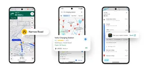
Get alerts for accident-prone areas
To help you drive more safely and confidently, we're launching Accident-Prone Area Alerts, a new feature designed for India and built in partnership with government authorities. Now, based on authoritative data from city authorities, Maps will alert you – visually and through voice–as you approach these areas on your route, so you can slow down and drive safely. We’re starting to roll this out to Android users in Gurugram, Cyberabad, Chandigarh, and Faridabad.
See official speed limits
We're mapping authoritative speed limit data from local traffic authorities in Google Maps. While navigating, Maps will display the official speed limit for your road—right next to the speedometer in the app—helping you drive with more confidence. This is rolling out to both Android and iOS users in 9 Indian cities: Faridabad, Ghaziabad, Gurugram, Hyderabad (including Cyberabad), Jaipur, Kolkata, Lucknow, Mumbai, Noida.
Authoritative highway information in partnership with NHAI: To ensure you have the most reliable information on highway conditions, we're also announcing the start of a new partnership with the National Highways Authority of India (NHAI). As we begin this collaboration, NHAI will share near real-time, authoritative data on road closures and repairs, allowing us to reflect it on Maps for a more reliable navigation experience. This partnership will also enable us to surface information for wayside amenities like public restrooms, eateries, and petrol stations.
This deep collaboration with local partners is crucial to our shared goal of creating helpful and reliable experiences on Google Maps. While our AI, local partners, and the Maps community in India work tirelessly to keep the map updated, conditions can change rapidly. We encourage everyone to use Google Maps as a helpful guide but to always remain alert and exercise caution, keeping in mind the dynamic nature of real-world situations.
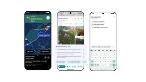
This is part of the 10 new updates we’re introducing to make your everyday journeys more seamless, intuitive, and safer with Google Maps. Read on to learn more about how we're Supercharging Maps with Gemini and launching new India-First Travel Features.