Helping public health officials, around the world and in MENA, combat COVID-19
As communities around the world respond to the COVID-19 pandemic, there has been an increasing emphasis on public health strategies, like social distancing measures, to slow the rate of transmission. In Google Maps, we use aggregated, anonymized data showing how busy certain types of places are—helping identify when a local business tends to be the most crowded. We have heard from public health officials that this same type of aggregated, anonymized data could be helpful as they make critical decisions to combat COVID-19.
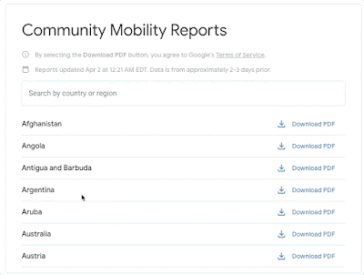
Community Mobility Reports
Starting today, we’re publishing an early release of our COVID-19 Community Mobility Reports to provide insights into what has changed in response to work from home, shelter in place, and other policies aimed at flattening the curve of this pandemic. These reports have been developed to be helpful while adhering to our stringent privacy protocols and policies. Reports will be available for many countries around the world including Egypt, Jordan, Lebanon, Saudi Arabia and the United Arab Emirates. More country reports are available on the site.
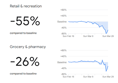
The reports use aggregated, anonymized data to chart movement trends over time by geography, across different high-level categories of places such as retail and recreation, groceries and pharmacies, parks, transit stations, workplaces, and residential. We’ll show trends over several weeks, with the most recent information representing 48-to-72 hours prior. While we display a percentage point increase or decrease in visits, we do not share the absolute number of visits. To protect people’s privacy, no personally identifiable information, like an individual’s location, contacts or movement, is made available at any point.
We will release these reports globally, initially covering 131 countries. Given the urgent need for this information, where possible we will also provide insights at the regional level. In the coming weeks, we will work to add additional countries and regions to ensure these reports remain helpful to public health officials across the globe looking to protect people from the spread of COVID-19.
Navigate and download a report for your country of interest.
In addition to other resources public health officials might have, we hope these reports will help support decisions about how to manage the COVID-19 pandemic. For example, this information could help officials understand changes in essential trips that can shape recommendations on business hours or inform delivery service offerings. Similarly, persistent visits to transportation hubs might indicate the need to add additional buses or trains in order to allow people who need to travel room to spread out for social distancing. Ultimately, understanding not only whether people are traveling, but also trends in destinations, can help officials design guidance to protect public health and essential needs of communities.
In addition to other resources public health officials might have, we hope these reports will help support decisions about how to manage the COVID-19 pandemic. For example, this information could help officials understand changes in essential trips that can shape recommendations on business hours or inform delivery service offerings. Similarly, persistent visits to transportation hubs might indicate the need to add additional buses or trains in order to allow people who need to travel room to spread out for social distancing. Ultimately, understanding not only whether people are traveling, but also trends in destinations, can help officials design guidance to protect public health and essential needs of communities.
Community Mobility Report for the United Arab Emirates.
Privacy protections
The Community Mobility Reports are powered by the same world-class anonymization technology that we use in our products every day. For these reports, we use differential privacy, which adds artificial noise to our datasets enabling high quality results without identifying any individual person.
The insights are created with aggregated, anonymized sets of data from users who have turned on the Location History setting, which is off by default. Users who have Location History turned on can choose to turn the setting off at any time from their Google Account, and can always delete Location History data directly from their Timeline.
These are unprecedented times and we will continue to evaluate these reports as we get feedback from public health officials, civil society groups, local governments and the community at large. We hope these insights will add to other public health information that will help people and communities stay healthy and safe.
This post is an amended version of the blog post published by Google Senior Vice President, Jen Fitzpatrick & Google’s Chief Health Officer, Karen DeSalvo.