Explore and share New Zealand’s beautiful landscape with updated Street View imagery
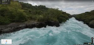
Today we’re making our Street View coverage in New Zealand more up-to-date, by publishing new imagery of the North and South Islands. The new panoramic imagery includes major cities, such as Auckland and Christchurch, along with hundreds of kilometres filled with breathtaking mountains, coastal roads and snow capped peaks.
Whether you’re planning a trip for the weekend or trying to entice overseas guests to visit New Zealand, you can now discover and share the most northern point, the tranquil Mission Bay, the mighty Mount Ruapehu or even drop by some vineyards around Blenheim.
View Larger Map
The updated imagery will also help you navigate more easily through urban areas like Auckland and Christchurch, reflecting recent changes within certain areas in both cities. So, whether you’re choosing between different restaurants for dinner or deciding which hotel to stay in for a business trip, it’s now easier to find what you need to find and get to where you need to go.
Over the last month, we’ve been working on some other mapping projects as part of our ongoing efforts to provide Kiwis with the most accurate, comprehensive and easy-to-use maps. In August, we started our journey through two of New Zealand’s magnificent Great Walks using Trekker and just last weekend we worked alongside the citizens of Christchurch to make thousands of edits to local business information in the city’s CBD.
We hope you enjoy taking a virtual drive through New Zealand’s beautiful landscapes. Happy exploring!