Discover South Africa's national parks, nature reserves and UNESCO World Heritage Sites
Over the past 12 months, myself and my team at Drive South Africa have had the privilege of exploring some of South Africa’s most beautiful natural and cultural locations. Even better, today we are able to share the results of that exploration with a global online audience.
That we were able to do so, is thanks to Google’s Street View Loan Camera Program, which allows ordinary people from around the world to help Google map the planet. As the first third-party organisation in South Africa to be a part of the program, we know we had a massive responsibility on our shoulders.
The results, we believe, speak for themselves.
Thanks to the efforts of more than 200 volunteers, Street View users can access 170 new trails in South Africa’s wildest locations. These volunteers, who come from all walks of life, hiked, walked, waded and trekked through South Africa national parks, nature reserves and dozens of culturally and historically significant sites in all nine provinces of South Africa.
- The Kruger National Park is South Africa’s oldest wilderness area. When in the park, visitors may only walk on wilderness trails, led by specialist rangers.
- Crossing the Bloukrans River crossing, on day four of the five-day Otter Trail hiking trail. The Otter Trail is South Africa's most popular hiking trail, often booked out a year in advance.
As a consequence, ordinary people can walk in the footsteps of struggle icon Nelson Mandela, climb seven new trails to the top of Table Mountain, hike the famous five-day Otter Trail, track cheetah on foot, and walk with elephant and other incredible wildlife (the trekkers were guided by qualified rangers in all wilderness areas), to mention a few.
Users can also explore South African UNESCO World Heritage Sites, such as Mapungubwe Hill, home to an ancient African civilisation, the Richtersveld with its arid moonscapes, the towering Drakensberg Mountains, and iSimangaliso Wetland Park, South Africa’s oldest UNESCO site and a critical habitat for a range of species.
- The infamous chain ladders, a daunting part of the Tugela Falls Hiking trail in South Africa's Drakensberg Mountains, a UNESCO World Heritage Site of both cultural and natural significance.
- The Nelson Mandela Capture Site in South Africa's KwaZulu-Natal province. Tour guide Lyanda Nyandeni, helped collect these images at the historic location that marks the spot where Mandela was arrested before his 27-years’ imprisonment.
While the Drive South Africa team worked hard to put all of this together, we wouldn’t have been able to achieve a fraction of what we have without the support and assistance of Google’s Street View Special Collects team.
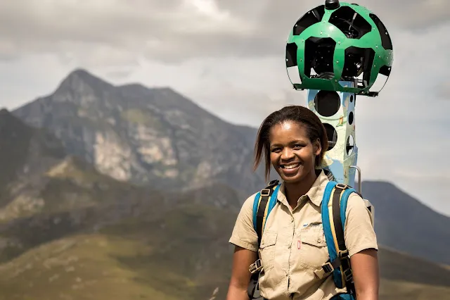
Mate Modisha, a field ranger at Cape Nature’s Grootvadersbos Nature Reserve is one of 206 South Africans to carry the Google Trekker camera. Grootvadersbos is a lesser-known reserve, just a few hours from Cape Town.
To explore South Africa’s wildest regions on Google Street View, head over to the Discover South Africa Street View gallery or take a virtual journey through South Africa with an interactive microsite. The virtual experience combines Street View imagery with video, photos, audio and stories captured during the trekking team’s 50 000km journey around South Africa.
The project, which was supported by South Africa Tourism, SANParks, CapeNature, KZN Ezemvelo Wildlife, Wesgro, dozens of other local tourism organisations and hundreds of South African volunteers, is a vibrant example of the ancient African philosophy of Ubuntu enabled by modern technology.


