AI continues to supercharge Google Maps for India
Our goal with Google Maps has always been to organize information about the real-world and make it accessible and useful for everyone. And along this journey, AI has supercharged the way we map for nearly a decade, enabling us to build a comprehensive, up-to-date, and helpful map that's at the foundation of everything we do.
In India, it's allowed us to map millions of kilometers of urban and rural roads and more than 300 million buildings. This is serving millions of users on a daily basis, on average surfacing over 50 million searches across multiple languages, and powering over 2.5 billion kms of directions every single day on Google Maps in India. Our AI technology has made commute decisions more seamless, helping people choose the most time-efficient route with traffic predictions.
AI has also helped us put over 30 million businesses and places on Google Maps in India, helping people make everyday decisions with useful information such as business hours, photos, videos, and reviews. This enables over 900 million connections a month between consumers and businesses in India through Google Search and Google Maps. AI is also helping us unlock real-world societal benefits. For example, it’s enabling us to analyze traffic patterns to support cities in optimizing the traffic flow at intersections with Project Greenlight.
As we think about the future of Google Maps in India we continue to focus on unlocking the immense power of digital mapping with AI, along with the support of our local partners, to deliver richer solutions that can benefit everyone – users, businesses, and society. We’re focussed on three key areas:
- Building a richer and more comprehensive map localized for the needs of Indian users
- Building a more visual and immersive map to transform the way users navigate and explore the world.
- Catering to India’s diverse mobility needs, from public transport to sustainable journeys
Today we are sharing a few ways we're bringing this vision to life with new India-first and India-focussed innovations.
Building a richer and more comprehensive map localized for the needs of Indian users
The last few years, we have been investing in adding more places and businesses to the map, especially those that Indian users often search for. This includes places of worship, medical facilities and government services. These places of interest (or POIs) are also the landmarks that people use to communicate their addresses - behind a school or next to the local post office.
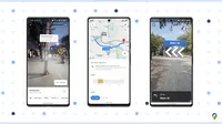
We're introducing a new India-first innovation, Address Descriptors on Google Maps, to help our users understand addresses better, in a way they are used to in real life.
Dropping a location pin on Google Maps and sharing it with friends and family is a very common practice in India. Using a combination of machine learning signals Google Maps will automatically find up to five of the most relevant landmarks and area names around your pinned address, and display the landmark reference when you share your location. This will make it easier for users to locate these addresses in unfamiliar areas. We’re looking forward to rolling this to our users across India early next year.
We launched this capability earlier this year for developers in India on Google Maps Platform to help them benefit from more intuitive addressing solutions. We’re now expanding this to developers across over 75 cities in the country.
More visual and immersive map to transform the way users navigate and explore the world
We believe the next frontier of Google Maps is helping people go from knowing about a place to truly experiencing it. We took a fundamental step in this journey with the launch of Street View in India last year. Combining AI technology and imagery from our local partners, Genesys International and Tech Mahindra, people in India are able to view and explore over 3,000 cities and towns nationwide.
Next, you’ll be able to easily understand your surroundings with Lens in Maps. Imagine you are in a busy market and need to make a quick decision on where to eat with your friends. Simply point your camera down the street and you will instantly see nearby restaurants and cafes, as well as useful information like opening hours, ratings, reviews and photos. Lens in Maps will be launching in 15 cities across India by Jan 2024, starting with Android.
Prefer walking? We are excited to bring Live View walking navigation to India. With this feature, you will see arrows, directions, and distance markers overlaid on the Maps screen, helping you quickly figure out which way to head in. Your phone will also vibrate when it’s time to make a turn or you’ve reached your destination. Live View walking navigation is coming to over 3,000 cities and towns in India, starting with Android.
We’re bringing innovations like Lens in Maps and Live View walking navigation to India by combining Street View imagery along with advanced AI and AR technologies to create these immersive experiences.
Catering to India’s diverse mobility needs, from public transport to sustainable journeys
We have hundreds of millions of users coming to Google Maps monthly to get multi-modal directions and for navigation. This includes walking, two wheelers, four wheelers, public transport and more.
For driving, as people become more conscious of their carbon footprint, we are bringing our fuel-efficient routing feature to India. From its launch in other countries, from October 2021 through September 2023 it’s already estimated to have helped prevent more than 2.4 million metric tons of CO2e emissions globally — the equivalent of taking approximately 500,000 fuel-based cars off the road for a year. By January next year, users across India will be able to access this feature for four-wheelers as well as two-wheelers, offering more sustainable alternatives. India and Indonesia will be the first countries in which we’re rolling out this feature for two-wheelers.
We apply AI to understand real-time traffic data, road elevation, and even your vehicle's engine type, to identify the route that minimizes fuel and emissions. For example, hybrid and electric vehicles perform better in stop-and-go traffic, while diesel engines use less fuel at higher speeds. This helps save fuel and encourage sustainable route choices, without significantly impacting travel time.
A large majority of people in India depend on public transport for their daily mobility needs. Over the years, we have partnered with numerous local authorities towards this goal, enabling millions of users to find information about various modes of public transport including metros, trains, and buses in over 20 Indian cities. We’re excited to share new ways we’re doing this across our Google products.
Starting with one of our most-loved products – the Where Is My Train app. Every month, more than 80 million people use the Where Is My Train app to navigate intercity train journeys, enabling people to access dynamic information like schedule changes, delays, and platform numbers, which might not be easily accessible otherwise. Today we are announcing expansion of Where Is My Train to cover Mumbai and Kolkata Local Trains, with more cities to come.
We’re also delighted to announce partnerships with ONDC and Namma Yatri to deliver on our vision of enabling a more digitized public transport experience accessible to all users.
ONDC is revolutionizing the way people avail goods and services online across various sectors, including mobility. We’re collaborating with ONDC as they digitize public transport at scale. To bring this vision to life, we are announcing a partnership with Namma Yatri, a leading mobility app on the ONDC network, that will focus on bringing metro schedules and bookings to users. By mid next year, we’ll launch Kochi metro on Google Maps powered by Namma Yatri, and follow with other metros as they join the ONDC network. We are excited to be a part of this mobility transformation journey in India.
- T Koshy, MD and CEO at ONDC: "We are excited to collaborate with Google Maps towards revolutionizing public transport experiences in India. With this collaboration, we aim to not only enhance user convenience but also provide a platform for the growth of mobility startups nationwide. Together, our pilot initiative with Kochi Metro and Namma Yatri sets the stage for a more efficient and discoverable transportation landscape. Furthermore, as we strive for a future where various modes of transport seamlessly connect, our collaboration with Google Maps holds the promise of unlocking new levels of accessibility, affordability, and transformative possibilities."
- Vimal Kumar, Founder and CEO of Juspay: “Technology can drive up the adoption of public transport by making it seamless and super convenient. We believe Namma Yatri’s citizen/community-first approach, combined with deep technological innovation, can help transform this space. We are happy for this partnership with ONDC who plays a critical role in bringing the ecosystem players together, and with Google Maps whose ubiquity can take this innovation to all the citizens towards a positive impact.”
Across our journey spanning over 15 years, we’ve consistently invested in building a truly helpful and local Maps for India, and we look forward to making digital mapping even more helpful for users, society, and businesses by building the future of Google Maps right here in India, with the power of AI.