Street View goes to the “top of the world”
Editor’s Note: Today’s post comes from Emma Upton, Quttinirpaaq National Park Manager with Parks Canada. She shares the story behind our new Street View collection that captures the beauty of Canada’s Quttinirpaaq National Park.
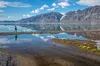
Here at Parks Canada, we have a lot to say about Quttinirpaaq National Park. We could tell you it’s the northernmost park in Canada, or that it lies roughly 500 miles (800 kilometers) from the North Pole. We could tell you it’s home to 4000-year-old archeologist sites or that it’s the second-largest national park in the country. But, we don’t need to tell you anymore. Now we can show you, with our new Street View collection.
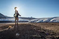
Last summer, our team threw on the Google Trekker and explored the park’s incredible terrain—it was the furthest north Street View has ever gone. Wilderness and extreme isolation characterize this area, where fewer than 50 people visit each year. The park’s name itself translates to “the top of the world” in Inuktitut, the local indigenous language.
With treks along the ocean shoreline, climbs up to lofty ridges, strolls beside glacial melt-water rivers, and scrambles at the foot of monumental glaciers, the resulting imagery is spectacular—a digital reflection of one of the world’s most rural locations
Aside from Quttinirpaaq National Park, we captured Street view imagery of Grise Fiord, Canada’s northernmost community, and Resolute Bay, which has a population of just under 200 people.
Internet access and bandwidth are challenging in this part of the world, but we wanted the people who live in and around the area to be able to enjoy the new Street View collection. We revealed the imagery, as well as the behind-the-scenes story of how it was captured, at an event hosted by Parks Canada. And we were moved to see how excited people were to see their remote home online for the world to explore.
See all the highlights in this gallery, and a few photos of our trek below:

![Parks Canada staff member hikes near Air Force Glacier with the Google Trekker. Quttinirpaaq National Park, Nunavut, Canada. [FRENCH] Un membre de l'équipe de Parcs Canada se promène près du glacier situé sur la boucle Air Force, po.jpg](https://storage.googleapis.com/gweb-uniblog-publish-prod/images/Parks_Canada_staff_member_hikes_n.width-100.format-webp.webp)


