Advanced Flood Hub features for aid organizations and governments

Floods continue to devastate communities worldwide, and many are pursuing advancements in AI-driven flood forecasting, enabling faster, more efficient detection and response. Over the past few years, Google Research has focused on harnessing AI modeling and satellite imagery to dramatically accelerate the reliability of flood forecasting — while working with partners to expand coverage for people in vulnerable communities around the world.
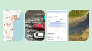
Today, we’re rolling out new advanced features in Flood Hub designed to allow experts to understand flood risk in a given region via inundation history maps, and to understand how a given flood forecast on Flood Hub might propagate throughout a river basin. With the inundation history maps, Flood Hub expert users can view flood risk areas in high resolution over the map regardless of a current flood event. This is useful for cases where our flood forecasting does not include real time inundation maps or for pre-planning of humanitarian work. You can find more explanations about the inundation history maps and more in the Flood Hub Help Center.
Flood Hub inundation history map layer around Nigeria
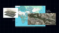
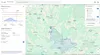
With the basin view per gauge the Flood Hub can support flood experts to identify the best forecast location for tracking such as a village, hospital or shelter on the map and more.
Flood Hub with selected gauge and its basin
The new updates in Flood Hub have more to offer flood experts at aid organizations, governments and research groups. For example, a new layers panel allows users to add and remove different layers from the map, making it possible to better understand each of the layers separately, now that more information is available on the Flood Hub. An enhanced gauge panel and updated Help Center provide detailed explanations of the Flood Hub features and abilities, including information about the different flood models presented there.
How these new tools support field work
Our flood forecasting tools, such as the Flood Hub, Floods API and the historical dataset are designed to support aid organizations, governments and researchers who can benefit from granular and long lead time flood information. One reason we’re focused on working with these groups is that they have operative systems in place to deliver advanced warnings and preemptive relief. During 2024, we saw the outputs of these efforts first-hand through our partnerships with Give Directly and the International Rescue Committee (IRC) in Nigeria and Bangladesh. This collaboration enables aid organizations to use our technology in their response, and helps communities become more resilient to future floods.
Support for AI-powered flood relief in Nigeria
We previously shared progress from international partnerships that leverage AI for flood preparedness. In June of 2024, Google.org gave funding to Give Directly and the International Rescue Committee to help deliver cash support to 7,500 people in Nigeria.
GiveDirectly operated in Kogi state on the Niger river and IRC operated on the Benue river in eastern Nigeria. GiveDirectly used the Google Flood API alongside their anticipatory action systems to receive village-specific alerts and initiate cash transfers.
“With Google's historical data, we identified the areas most at risk of flooding,” explains Federico Barreras, humanitarian manager at GiveDirectly. “Using the Google Flood API, we determined when floods were about to hit our target areas, allowing us to deliver cash assistance ahead of the peak to those most in need.”
This collaboration resulted in a first-of-its-kind AI-powered cash relief effort in Africa, enabling cash aid to reach communities at least 5-7 days ahead of the flood peak in Nigeria, during September - October 2024. The goal with advance relief is to give families the financial means to secure food and protect their assets before disaster strikes. Research shows that knowing about a disaster prior to the event can not only increase your preparedness but also reduce the amount of money needed for the reaction to the disaster.
In addition to including the Google Flood API in their trigger logic that unlocked cash relief for 3,000 households in Adamawa State, the IRC is using the platform in other projects beyond Nigeria. Miles Murray, the IRC's Anticipatory Action Specialist, says: “We are replicating this approach of automating flood Anticipatory Action in other contexts as well, such as Northern Kenya, where previously there was no flood forecast data but with AI there are now dozens of reporting points enabling more families to benefit from AI-powered cash relief.”
Cash transfers support for affected families in Bangladesh
In Bangladesh, where the Jamuna River basin suffers from devastating annual flooding, GiveDirectly used Google’s Flood Hub to deploy AI-driven anticipatory action. Before the flood season that happened this year in July, families in high-risk areas received cash transfers, enabling them to purchase essentials and safeguard their property. This approach highlighted the power of AI in supporting flood forecasting and directly benefiting affected communities. “In Bangladesh, anticipatory action triggers are usually set at the district level, which covers large areas,” says Abir Chowdhury, Bangladesh interim country director, GiveDirectly. “With Google’s AI-powered forecasts, we piloted a more precise approach — delivering anticipatory cash at the village level to reach the most at-risk communities before floods hit.”
Looking ahead
As we continue to expand the Flood Hub’s coverage and improve its functionality, we remain committed to developing new tools that enhance flood preparedness, response and recovery worldwide. Our goal is to empower international organizations to act quickly, and help strengthen the resilience of local communities in the face of climate crises.
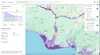
Government agencies, NGOs and researchers can access a free, shareable map of all river gauge data — past and forecasted — updated daily. Visit our Flood Forecasting research site to access Flood Hub or get more information.