Six ways we’re enabling more efficient and sustainable journeys on Google Maps in India, powered by AI and local partners

For nearly a decade, we've harnessed the power of AI and collaborated with local partners to make Google Maps more helpful for people in India, and customized to the needs of users across the country. By mapping over 7 million kilometers of roads, 300 million buildings, and 35 million businesses and places across India, we’ve been able to provide real-time traffic predictions, offer immersive experiences like Street View and Live View walking navigation, connect millions of consumers and businesses, and even tackle societal challenges like traffic congestion and flood forecasting.
Our quest to build a better Maps experience is never ending, and India presents many amazing opportunities to bring the best of our AI and geospatial technologies to address complex real-world challenges. Today, we're thrilled to share exciting new features that we're launching in India to make your navigation and exploration journeys more efficient and sustainable. Many of these solutions are being pioneered in India, for India. From a custom-built AI approach for tackling narrow roads and flyovers, to powering sustainable journeys with EV charging stations, as well as enabling the biggest community of maps contributors to surface real-time road disruptions on the map, we’re excited to bring such helpful features to millions across the country. India truly is at the center of our innovation, and we can’t wait to build the future of Maps right here.
Using AI to help four-wheeler drivers navigate narrow roads
Navigating narrow or congested roads in unfamiliar areas can be a challenge for four-wheeler drivers. We're introducing a new feature for Google Maps users in India designed to reduce the use of narrow roads when driving four-wheelers.

It starts with estimating road widths which is incredibly complex, given India's vast and diverse road network. To address this, we've developed an AI model specifically for Indian roads that incorporates multiple signals – satellite imagery, Street View, and other information like road types, distance between buildings, paved sections, etc. to estimate road widths at scale.
Using these road width estimates, we've fine-tuned our existing AI routing algorithms to help four wheelers avoid narrow roads whenever possible, without significantly impacting travel time or distance. This means four-wheeler drivers can enjoy a less stressful driving experience, and it also benefits bikers, pedestrians, and other commuters who can now use these narrow roads more safely and confidently.
Sometimes, taking a narrow road is unavoidable, especially if it is the only optimal way to get to your destination. Hence, we're adding clear callouts in Maps Directions and Navigation screens to alert you to narrow sections on your route, so that you can proceed cautiously or choose an alternative route.
The diversity of road types in India, makes this a complex challenge, and we won't always get it right. But we're committed to continuously learning and improving the feature based on what we see in the real world and listening to user feedback. We're starting to roll out this feature on Android devices this week in eight cities: Hyderabad, Bengaluru, Chennai, Coimbatore, Indore, Bhopal, Bhubaneswar, and Guwahati. We look forward to bringing this to iOS and more cities soon.
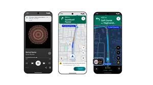
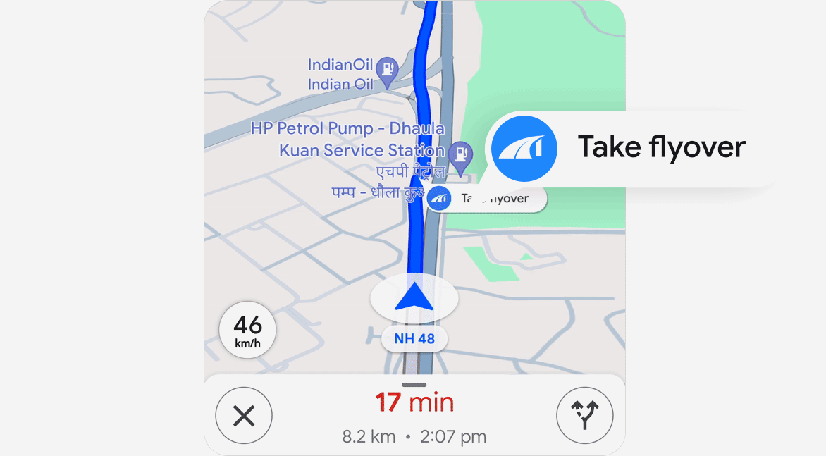
Navigate flyovers with confidence
Flyovers are prevalent in many cities across India. When you are in an unfamiliar part of the city, it could be a challenge figuring out whether your route requires you to take a flyover or stay on the service road. That's why we're introducing a new feature on Google Maps where we will call out flyovers along your recommended route. This feature helps you anticipate upcoming flyovers and prepare ahead of time to get onto the flyover.
Starting this week, you'll see these flyover callouts in 40 cities across India for both four-wheeler and two-wheeler active navigation on Android apps and Android Auto. iOS and CarPlay support will be coming soon.
Our Narrow Roads and Flyover features have been pioneered in India, for India tailored to the unique navigation needs of our users here. We'll soon be making these features available to developers through the Google Maps Platform Routes API. This means they can seamlessly integrate narrow road and flyover callouts into their own apps and services, creating even better location-based experiences for their users in India.
Supporting EV journeys with local partners
We want to ensure EV drivers have the tools they need to confidently hit the road. We're introducing helpful information about EV charging stations on both Google Maps and Google Search in India.
To achieve this, we're collaborating with leading EV charging providers in India – ElectricPe, Ather, Kazam, and Statiq – to add authoritative information for over 8,000 charging stations, representing a significant portion of available charging stations in India.
Now, you can easily find detailed information, including plug types (including those for two-wheelers) and real-time availability. You can even filter by your specific charger type and check if the station is open before you head over.
This marks the first time we are launching EV charging stations for two-wheelers on Google Maps, and India is the first country to get this feature. We look forward to expanding this coverage nationwide and will continue to improve the availability and reliability of real-time data.

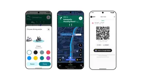
Metro ticket bookings powered by ONDC and Namma Yatri
Public transportation is a crucial part of India's mobility needs. Google Maps already provides millions of people with information about various modes of public transport, including metros, trains, and buses from numerous local authorities.
Last December, we announced an exciting collaboration with ONDC and Namma Yatri to streamline the public transport experience on Google Maps. This metro booking experience in Google Maps is now going live in Kochi and Chennai, powered by ONDC and Namma Yatri.
Starting this week, Google Maps will make your metro journeys in Kochi and Chennai even smoother, allowing you to book your tickets via Google Maps, powered by ONDC and Namma Yatri. Now, when you search for public transport directions in these two cities, you'll start seeing a new booking option for the metro leg of your trip. With a simple tap, you'll be guided through the booking and payment process, powered by ONDC and Namma Yatri, eliminating the need to wait in line at the station.
We're eager to expand this feature to more cities and additional modes of public transport, collaborating closely with Namma Yatri and ONDC to enhance your public transportation experience.

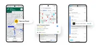
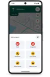
Easily report incidents to help your community
One of the things that makes Google Maps so special is our passionate community of local contributors. India boasts the largest such community in the world, with over 60 million people sharing millions of reviews, photos, business edits, and road updates every day. This wealth of authentic, real-world information is a helpful resource for people navigating their everyday lives. We’re always looking for ways to make it easier for users to share valuable information to help the community.
We've simplified how you can report road incidents. Whether there’s ongoing construction or a traffic mishap on your route, you can now report it with just a few taps, making it easy and less distracting. You can even confirm others' reports with a single tap which helps increase confidence in these user reported incidents. This update is available in India on Google Maps across all platforms - Android, iOS, Android Auto, and Apple CarPlay.
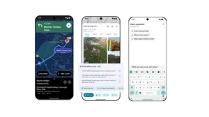
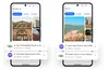
Curated lists of favourite spots from your community and local experts
To make the most of a trip, it’s important to get recommendations you can trust — so we’re making it easy to discover helpful lists from local experts and the Google Maps community.
We’ve made it easier than ever to create, share, and collaborate on lists of your favorite places. Imagine you're planning a trip to Jaipur with friends or family, with our updated "Lists" feature, you can all contribute to the itinerary, share recommendations, and even vote on where to go using emojis!
We have also collaborated with local experts like NDTV Food and magicpin. They've curated lists for ten major cities and tourist spots: Bengaluru, Delhi, Mumbai, Goa, Hyderabad, Pune, Ahmedabad, Chennai, Kolkata and Jaipur, offering insider tips and recommendations for the best places to eat, drink, and explore. Now, when users search for these places on Google Maps, they’ll find lists like "Best Ocean-View Cafes in Goa," or "Top Breakfast Spots in Mumbai,"or “Best shops to get Sandesh in Kolkata”.
These new features reaffirm our commitment to making digital mapping even more helpful for users, businesses, developers, and society at large. We look foward to continuing our journey of innovation in India.