Wildfire boundary maps expand to new countries in Europe and Africa

General summary
Wildfires are becoming more frequent and severe due to climate change, with recent devastating events in Europe and Africa. To help combat this, Google is expanding its AI-powered wildfire boundary tracking tool to 15 new countries in these regions. This tool provides detailed, accurate, and accessible information about wildfires, including alerts and safety tips, in multiple languages. It is designed to assist both locals and travelers in staying informed and safe during wildfire emergencies.
Summaries were generated by Google AI. Generative AI is experimental.Bullet points
- Wildfire boundary maps now available in 15 countries across Europe and Africa.
- Uses AI to track wildfire boundaries in near real-time using satellite imagery.
- Provides accurate and reliable information to help people stay safe.
- Accessible through Search, Maps, and location-based push notifications.
- Part of Google's efforts to use AI to help communities adapt to climate change.
Explore other styles:
During one week in July, according to reports, firefighters fought through the night as wildfires blazed on the Greek islands of Kos, Chios and Crete. Authorities in the Spanish community of Extremadura activated 60 personnel to control a forest fire — one of 18 threatening the region. One wildfire, according to reports, in the Paphos region of Cyprus, was caused by light refracted through broken glass. According to estimates, territory that is fire-prone in Europe has doubled in the last 50 years.
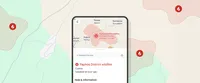
Using AI, we are able to show detailed wildfire boundary tracking in Search and Maps and through location-based push notifications. Now, during this record-breaking summer, we are expanding* this tool to 15 countries across Europe and Africa:
- Andorra
- Bosnia & Herzegovina
- Croatia
- Cyprus
- France
- Greece
- Italy
- Kenya
- Monaco
- Montenegro
- Portugal
- Rwanda
- Slovenia
- Spain
- Türkiye
We’re surfacing this information through alerts and features that provide information about how to stay safe to people who are near a wildfire.
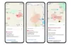
Accurate and reliable tracking
Google’s AI-powered wildfire tracking model is trained on multiple sources of data, including a variety of satellite imagery data sets. We also validate our wildfire model by comparing it against our own model of fire scars — shapes determined after a fire has been contained — based on measurements from past wildfire events. Other AI models are used to verify the existence of fires, and together all of this enables more accurate and definitive wildfire boundaries than using satellite imagery alone.
Accessible and useful information when people need it
As we were rolling out this new capability this summer, we mapped over 40 wildfires in southern Europe, including fires in Spain, Greece and Cyprus last month — and others from Portugal to Kenya.
We showed these wildfire boundaries in Search and Maps and made information available through notifications — complementing existing on-the-ground efforts to help people access information and stay safe. As many as 1.4 million people saw our wildfire information in the first week of July alone, after wildfires broke out across Europe and Africa.
Wildfire boundary tracking aims to be useful on the ground to both native language speakers and visitors who may not speak the local language. These notifications are based on user settings and their preferred language, giving travelers during tourist season ways to receive timely, local information about wildfires in their language.
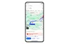
Information is also overlaid on Google Maps driving directions, helping travelers understand whether their directions may have wildfires near the route.
This is just one of the many ways we’re using AI to help communities around the world adapt to the impacts of climate change and the hazards it’s causing. We have launched this feature in countries that have been impacted by wildfires in recent summers and based on the quality of our model in each country. As we work to improve our models over time, we hope to expand to more countries and continue sharing critical information with people when they need it.
*Wildfire tracking is already available in the US, Canada, Australia, Brazil, Argentina, Chile and Mexico.