New updates and more access to Google Earth AI


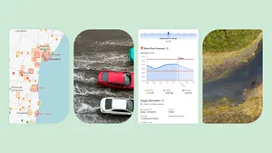
When disasters strike, Google products like Search and Maps help billions of people make critical decisions to stay safe. Our flood forecasting information — now covering more than two billion people — provides life-saving forecasts before the most significant river floods. It's helped organizations like World Vision get drinking water and food to communities when they need it most. And during the devastating 2025 California wildfires, we provided crisis alerts with information from local authorities to 15 million people across Los Angeles while showing them where to find shelter in Google Maps. This is all made possible by our geospatial AI models, not only for floods and wildfires, but cyclones, air quality and many more.
We recently introduced Google Earth AI, bringing together these geospatial models to help tackle the planet's most critical needs. Earth AI is built on decades modeling the world, combined with state of the art predictive models and Gemini’s advanced reasoning, letting enterprises, cities and nonprofits achieve deeper understanding in minutes — efforts that previously required complex analytics and years of research.
Today, we’re advancing Earth AI’s innovations and capabilities, and expanding access around the globe. Here’s how:
Connecting the dots with Geospatial Reasoning
To solve a complex problem, you need to see the whole picture, not just one piece of it. That’s the idea behind Geospatial Reasoning, a framework powered by Gemini that now lets AI automatically connect different Earth AI models — like weather forecasts, population maps and satellite imagery — to answer complex questions.
Instead of just seeing where a storm might hit, our latest research demonstrates that analysts can use Geospatial Reasoning to identify which communities are most vulnerable and what infrastructure is at risk, all at once. For example, Geospatial Reasoning empowers the nonprofit GiveDirectly to respond to disasters by combining flood and population density information, helping them identify who needs direct aid most.
Sign up for consideration to become a Trusted Tester for Geospatial Reasoning. Social impact organizations can learn about future support for nonprofits through Google.org and our non-commercial access programs.
Getting deeper insights in Google Earth
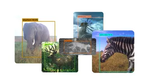
Gemini capabilities in Google Earth enable analysts to quickly understand information about the world just by asking questions. Now, we’re bringing new Earth AI models to Gemini capabilities in Google Earth, letting users instantly find objects and discover patterns from satellite imagery.
For example, a water company can now spot where a river has dried up — which can help communities predict the risk of dust storms during a drought — and notify people in advance. Or, analysts can quickly identify where harmful algae is blooming in order to monitor drinking water supply, giving authorities time to issue warnings or shut down water utilities.
This experimental capability will be available in the U.S. in the coming weeks to Google Earth Professional and Professional Advanced users. And starting today, Google AI Pro and Ultra subscribers in the U.S. can access Gemini capabilities in Google Earth with higher limits.
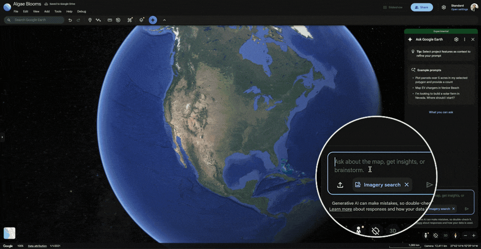
Finding algae blooms within Google Earth imagery.
Bringing Earth AI to Google Cloud
We’re making Earth AI Imagery, Population and Environment models directly available to Trusted Testers on Google Cloud. Businesses can now use their own data alongside our models and datasets, like Imagery Insights, to tackle specific challenges from environmental monitoring to disaster response.
Earth AI in Action
We’ve begun piloting Earth AI with thousands of organizations, including:
- The World Health Organization Regional Office for Africa (WHO AFRO) is using Earth AI’s Population and Environment models, along with their own datasets, to understand and predict which areas in the Democratic Republic of Congo are at risk for cholera outbreaks. This information enables experts to help manage water, sanitation and vaccinations.
- Satellite imagery providers like Planet and Airbus are using Earth AI models to analyze the billions of pixels they capture daily. Planet looks at historical satellite imagery to help customers map deforestation. Airbus uses Earth AI to help customers detect where vegetation is encroaching on power lines, so they can prevent outages.
- Bellwether, a moonshot at Alphabet's X, is using Earth AI to provide hurricane predictions insights for global insurance broker McGill and Partners. This enables McGill's clients to pay claims faster so homeowners can start rebuilding sooner.
These updates will make it easier to take action with Earth AI. We're working with partners to train Earth AI models to reason about the physical world as fluently as LLMs reason about the digital one so that we can support those building solutions for their communities, solving problems in public health, crisis response and beyond.