How we’re using AI to combat floods, wildfires and extreme heat
From experiencing the hottest summer on record to dealing with frequent and devastating floods and wildfires, the effects of climate change are already here and impacting all of us — particularly the most vulnerable communities. As cities and individuals work to address the effects of climate change, we believe AI can play a transformative role.
We’re working to build more solutions — like our AI-based predictions and forecasting — that provide actionable information to help individuals stay safe and communities plan ahead. Here’s some of the progress we shared today at Sustainable with Google.
Forecasting floods in more places
Floods are the most common natural disaster, causing thousands of fatalities and disrupting the lives of millions every year. Since 2018, Google Research has been working on our flood forecasting initiative, which uses advanced AI and geospatial analysis to provide real-time flooding information, to help inform communities and individuals to prepare for and respond to riverine floods. Our real-time flood forecasts and visualizations are available on the Flood Hub platform and, in many cases, also on Search and Maps.
Earlier this year, we expanded Flood Hub coverage to 80 countries, providing forecasts up to seven days in advance for 460 million people across Africa, the Asia-Pacific region, Europe and South and Central America. In August for example, Flood Hub was instrumental in providing information to Chile’s local emergency response agency so they could issue evacuation alerts, enable communities to take proactive measures, and minimize the impact of floods.
Today, we're announcing the expansion of riverine flood forecasts on Flood Hub to the U.S. and Canada, covering more than 800 locations by rivers where more than 12 million people live. With the help of AI, we hope to bring flood forecasting to every country and cover more types of floods, and we’ll continue to collaborate on this with our partners in the community, governments, academia, and organizations like the World Meteorological Organization.
Flood Forecasts are displayed on our Flood Hub platform for over 80 countries now including the U.S. and Canada.

Tracking wildfire boundaries and predicting fire spread
As wildfires become more frequent, we’re working to provide information about where fires are — and we’re also exploring how AI can predict where a fire will spread. In 2023, our SOS alerts have provided timely safety information to over 30 million people across 120 wildfire events around the world. To help map fire boundaries, our wildfire boundary tracker uses AI and satellite imagery to map large fires in close to real-time and updates every 15 minutes. This is available on Google Search and Maps in fire-prone parts of the U.S., Canada, Mexico and Australia, and we are working to expand coverage.
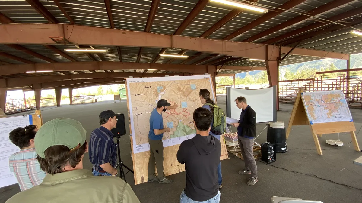
In addition to knowing where wildfires currently exist, firefighters need to anticipate where they will go and how to mitigate them well before they start. I’m excited to share that we are collaborating with the U.S. Forest Service to make the biggest updates to their current fire spread model in 50 years. This model leverages machine learning (ML) to model more fire dynamics to help fire authorities train firefighters, plan effective fuel treatments, and battle large-scale fires more safely and effectively while in the field.
Google Research team visiting the U.S. Forest Service Fire Science Lab.
Helping people and cities respond to extreme heat
Extreme heat also impacts public health, and heat-related deaths are on the rise. We launched extreme heat alerts this year so when people search for information on extreme heat, they see details about when a heat wave is predicted to start and end, tips on staying cool and related health concerns to be aware of from the Global Heat Health Information Network (GHHIN). Since launching, we’ve provided information about extreme heat on Search in more than 80 countries.
Cities are also looking for ways to prevent “heat islands,” which are urban areas that experience higher temperatures due to structures like roads and buildings that absorb heat and re-emit it. Our Tree Canopy tool, part of our Environmental Insights Explorer platform, combines AI and aerial imagery to show where shaded areas are in the city, helping cities better understand where to plant more trees to reduce heat. Today, we’re expanding Tree Canopy data to more than 2,000 cities globally. Our goal is to help even more partners and cities access this information and make use of these insights. For example, we recently partnered with American Forests in the U.S. to make our tree canopy data available on their Tree Equity Score tool, ensuring shade in cities is equitably distributed. With this information, American Forests now provides tree canopy data for 260 million people – that’s nearly 80% of the U.S. population.
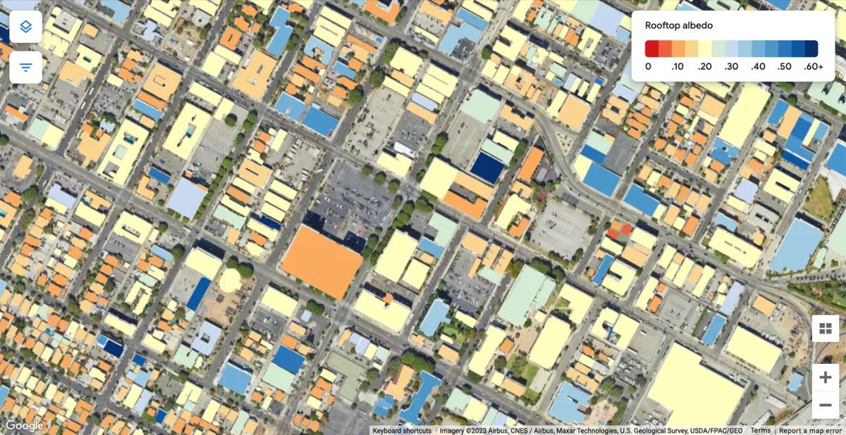
Another way we’re helping to reduce heat islands is by providing insights about reflective roofs — called "cool roofs". Our Cool Roofs tool uses AI and aerial imagery to map out the solar reflectivity of cities so urban planners and governments can identify which areas would benefit most from deploying a cool roof solution, such as a white roof. The pilot is live in four cities and will expand to 11 more cities in the coming weeks, including New York, Nashville and Melbourne.
Our Cool Roofs tool uses AI and aerial imagery to generate high resolution roof solar reflectivity measurements.
AI is already playing an important role in addressing the climate crisis. As we advance our AI research, we’ll do so boldly and responsibly to help further address the effects of climate change and help more people around the world.


