New ways AI is making Maps more immersive


From understanding a neighborhood at a glance to experiencing a place virtually like you’re really there, Maps has reimagined the way people navigate and explore. With advancements in AI, we’re introducing a whole new way to understand your route before you head out. Plus, developers can now tap into the magic of Maps’ immersive experiences.
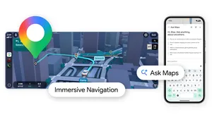
Preview your journey with Immersive View for routes
Over the past year, we’ve been reinventing Maps, making it more visual with features like search with Live View and Immersive View for places. Now with Immersive View for routes, you can visualize every segment of a route before you go — whether you're driving, walking or cycling.
Immersive View uses computer vision and AI to fuse billions of Street View and aerial images together to create a rich, digital model of the world. With this technology, you can see all the information you need about your route at once. When you get directions, you’ll see a multidimensional experience that lets you preview bike lanes, sidewalks, intersections and parking along your journey. With the time slider, you’ll see air quality information and how the route looks as the weather changes throughout the day, so you can be prepared with a jacket or sunscreen. And no matter what mode you take, AI and historical driving trends simulate how many cars might be on the road at a given time — because a route during a quiet afternoon can look very different during rush hour.
We'll begin rolling out Immersive View for routes in the coming months in Amsterdam, Berlin, Dublin, Florence, Las Vegas, London, Los Angeles, New York, Miami, Paris, Seattle, San Francisco, San Jose, Tokyo, and Venice.
Immersive View for routes puts all the information you need about your route in one place.
New ways for developers to build immersive experiences
We’re also helping developers build immersive experiences in their apps and websites with Google Maps Platform. With our new Aerial View API, available today in preview, developers can easily integrate a 3D birds-eye video of a point of interest into their apps, offering people more visual information about a place. Rent. is already using the Aerial View API to help renters visualize a property and its surrounding area so they can explore a neighborhood virtually and make more informed decisions about where to live.
Aerial View of Google's Spear Street office in San Francisco
For developers who want to customize their 3D maps, we’re now launching an experimental release of Photorealistic 3D Tiles via our Map Tiles API. We’re unlocking the high-res, 3D imagery behind Google Earth so developers can easily access the imagery to create immersive experiences unique to their brand without having to build the 3D map from scratch. For example, a tourism company can create a 3D map of a national park with photorealistic imagery of mountains, water and trees to entice travelers to visit. Or they can develop an interactive map tour of architectural landmarks, overlaying markers to share historical information in a virtual guided tour of the city.
Developers can now use the high-res, 3D imagery behind Google Earth to create immersive experiences.
These are just some of the ways we’re using AI to transform Maps and create immersive experiences. As we continue to make Maps even more helpful and intuitive, we’re excited to see the new experiences our developer community creates.