New Maps updates: Immersive View for routes and other AI features
Over the past few years, Google Maps has transformed how people interact with the world with features like eco-friendly routing to help you take fuel or energy efficient routes, and Live View to help you orient yourself when walking with augmented reality. Today with the power of AI, we’re announcing even more updates so you can confidently plan and navigate trips, make sustainable choices, and get quick inspiration for things to do.
Know before you go with Immersive View for Routes
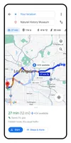
Google Maps provides over 20 billion kilometers of directions every day. And with AI, we’re reimagining how you plan your trips before you go. At I/O this year, we announced Immersive View for routes, an entirely new way to preview every step of your journey — whether you’re driving, walking or cycling. This week, Immersive View for routes starts rolling out in Amsterdam, Barcelona, Dublin, Florence, Las Vegas, London, Los Angeles, Miami, New York, Paris, San Francisco, San Jose, Seattle, Tokyo and Venice on Android and iOS.
Say you want to bike along the water to the Palace of Fine Arts in San Francisco. Just request cycling directions, then tap the Immersive View preview to see your route in a stunning, multidimensional view from start to finish. You can prepare for each turn as if you were there with detailed, visual turn-by-turn directions, and use the time slider to plan when to head out based on helpful information, like simulated traffic and weather conditions. That way, you can easily avoid riding during rainy weather or heavy traffic.
All of this builds on our work for Immersive View for places, which uses AI to fuse together billions of Street View and aerial images so you can know what a restaurant or landmark is like before you go. Now developers can also create their own immersive experiences with the launch of Photorealistic 3D Tiles in Google Maps Platform this week.
Easily understand your surroundings with Lens in Maps
Google Maps also makes it easier to understand your surroundings once you get somewhere — like if you’re exiting a subway station and need to orient yourself or if you’re scoping out a new neighborhood and need to find the nearest coffee shop. Lens in Maps (formerly called Search with Live View) uses AI and augmented reality to help you quickly acclimate yourself — whether you’re navigating a new city or discovering local hidden gems.
Simply tap the Lens icon in the search bar and lift your phone to find information about nearby ATMs, transit stations, restaurants, coffee shops and stores. In our biggest expansion of this feature yet, starting this week Lens in Maps is coming to more than 50 new cities including Austin, Las Vegas, Rome, São Paulo and Taipei.
Navigate with confidence with a more detailed map
Today, hundreds of millions of drivers depend on Google Maps’ helpful information about real-world conditions, like nearby crashes or upcoming traffic jams.
Soon, the navigation map will reflect the real world even more accurately. In addition to updated colors throughout the map, you’ll see more realistic buildings to help you better orient yourself - like if you’re driving downtown and need to understand where you are during the final stretch of your ride. And on highways, where some of the trickiest driving maneuvers often happen (like that annoying exit that requires you to quickly cross multiple lanes), you’ll see improved lane details to help you feel prepared. These updates start rolling out in the coming months in 12 countries, including the U.S., Canada, France and Germany.
In the U.S., you’ll soon see if there are HOV lanes along your route so you can make a more informed decision about how to get to your destination. And in Europe, our AI-powered speed limit information is expanding to 20 countries so you can stay safe even when it’s hard to spot speed limit signs on the road. Both features start rolling out on Android, iOS, and for cars with Google Built-in in the coming months.

Reduce charging anxiety with even more EV information
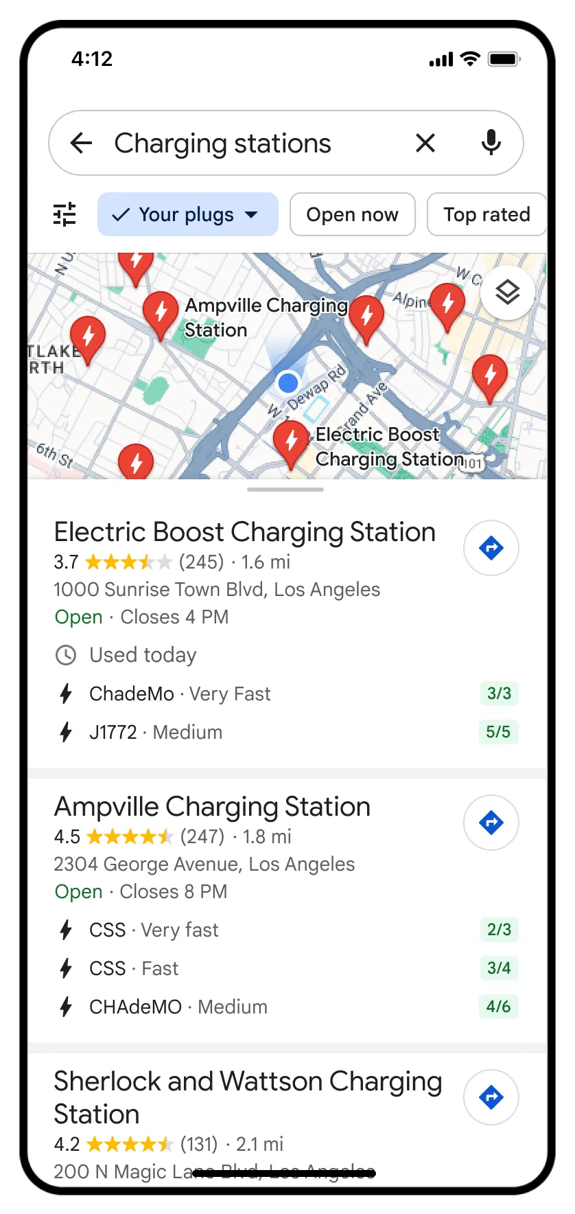
If you’re an electric vehicle driver, you may be familiar with charging anxiety. Whether you’re on a road trip, commuting to work, or heading across town, there’s nothing worse than not knowing where you can charge mid-trip.
Starting this week, building on our capabilities in cars with Google built-in, EV drivers on Android and iOS will now see even more helpful charging station information, including whether a charger is compatible with their vehicle and whether the available chargers are fast, medium, or slow to help you find the charging station that best meets your needs. And since roughly 25% of all chargers in the U.S. are down at any given time, you can also see when a charger was last used to help you avoid wasting time heading to a broken charger. These updates start rolling out globally on iOS and Android this week wherever EV charging station information is available.
EV charging information will also be available to developers on Google Maps Platform in the Places API, so companies can show real-time EV charging station information in their websites and apps.
Find inspiration for things to do with new ways to search
Sometimes you know exactly what you want to do, but aren’t sure where to go. Search in Google Maps is evolving to give you even more answers to your questions, help you discover things to do, and find inspiration in a whole new way.
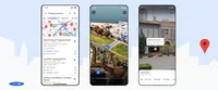
Now, when you search in Maps for specific things like the best place to find “animal latte art” or “pumpkin patch with my dog,” you’ll get photo-first results of what you’re looking for. These results are based on the analysis of billions of photos shared by the Google Maps community — all done with AI and advanced image recognition models. With this visual list of places, you can discover new spots that match exactly what you’re looking for. Just scroll through the results, tap on a photo to learn more, and navigate right there. This new way to search in Maps starts rolling out in France, Germany, Japan, the U.K. and the U.S. this week, and we’ll expand to more countries over time.
And for those times when you’re starting from scratch and have no idea what to do — like when you magically have a free weekend — you’ll soon see better-organized search results to spark your imagination. So if you’re in Tokyo, you could search for “things to do” to see thematic place suggestions like “anime”, “cherry blossoms” or “art exhibitions.” Tap on the places that interest you to learn more, and even save the options to a list if you want to check them out later. Thematic results for activities and dining roll out globally on Android and iOS in the coming weeks.
Google Maps is transforming how people explore and navigate, and AI continues to play a pivotal role in bringing how we’re building innovative experiences for people around the world.


